This is the post for those of you who have lots of questions about Belgium. While we don't want to bore you with too many details, we figured we ought to share a quick overview here.
 |
| image courtesy of Wikipedia |
Geography
Belgium is a small country located in Western Europe. With an area of 30,528 square kilometers (11,787 sq mi), it's about the size of the state of Maryland. It is very densely populated: over 11 million people live in Belgium, whereas only a little over half that many live in Maryland!
Belgium shares a border with the Netherlands to the north, Germany to the east, Luxembourg to the southeast, France to the south/southwest, and it has a small stretch of coastline bordering the North Sea on its western edge.
The country is divided into roughly three areas in terms of its topography or physical geography: you have the coastal area near the North Sea, full of sand dunes and flat flood plains (often protected by dikes, just like in the Netherlands), the central plain, with its gently (very gently!) rolling hills, perfect for farming (this includes the area around Leuven), and the Ardennes, the densely wooded and at times rocky and craggy area in the southwest of the country. The Ardennes are very popular for camping and outdoor sports, and aren't much good for farming due to the rugged landscape. As you can see from the map above, Belgium doesn't have much in terms of rivers or lakes, and its highest point, Signal de Botrange in the Ardennes, is only 694 meters above sea level. All in all, the terrain here isn't the most exciting or beautiful: Belgium is not the place to visit if you're interested in Europe's natural beauty.
Belgium shares a border with the Netherlands to the north, Germany to the east, Luxembourg to the southeast, France to the south/southwest, and it has a small stretch of coastline bordering the North Sea on its western edge.
 |
| typical Flemish countryside near Leuven, complete with a characteristic grey sky |
 |
| a typical cloudy sky over the Arenberg Castle in Heverlee |
Like most of its neighbors, Belgium has a maritime temperate climate, basically meaning that it's cool, wet, and cloudy for most of the year. Winters are mild and summers don't get all that hot, although this year we had an unexpectedly hot stretch in the mid to low 30s C (that's upper 80s and lower 90s F), even getting up to 36 C for a day or two (about 97 F!). It was quite unpleasant since nothing here is equipped for heat: very few buildings have air conditioning, window screens are an almost unheard of luxury, and even fans are hard to come by. It also tends to be quite humid here, so even temperatures in the lower 80s can become miserable pretty quickly.
 |
| the Atomium, as seen while taking off in Brussels |
The capital and largest city is Brussels, which is an important center for international politics. It serves as the capital of the European Union, and hosts four out of its seven principal governing institutions. The NATO headquarters can also be found in Brussels, in addition to the World Customs Organization, and over one thousand international charities and non-governmental organizations. You might also know it as home of the Manneken Pis and the Atomium.
Belgium's government is a federal parliamentary constitutional monarchy. (Don't ask me to explain what that means, though.) The current prime minister is Elio Di Rupo (yes, he's 100% ethnically Italian) and the newly-instated (as of July 2013!) monarch is King Philippe.
Belgium's government is a federal parliamentary constitutional monarchy. (Don't ask me to explain what that means, though.) The current prime minister is Elio Di Rupo (yes, he's 100% ethnically Italian) and the newly-instated (as of July 2013!) monarch is King Philippe.
Language and Culture
Now for the interesting part! Belgium, tiny though it may be, is home to three distinct cultural/linguistic groups. This has resulted in the division of the country into different regions and language communities, as you can see in the map below:

languages spoken:
Dutch
|
French
|
|
German
|
Dutch/French
|
|
image courtesy of Wikipedia
 |
| "knock please (bell doesn't work)" in Dutch/Flemish on an apartment window in Leuven |
The yellow part in the north is known as the Flemish Region, or Flanders, and it is home to the Dutch-speaking Flemish community. Flemish people are the majority, making up about 60% of the population.
Leuven is in Flanders, so where we live, everyone speaks the Belgian dialect of Dutch, known as Flemish. English is the second language here: signs are more likely to be in Flemish and English than in Flemish and French.
 |
| a McDonald's advertisement in French (complete with French flag!) in the Brussels Metro |
The red part in the south is known as the Walloon Region, or Wallonia, and it is home to the French-speaking Walloons, who make up about 40% of Belgium's population. Wallonia is also the home of the small population of German speakers, in the east along the border with Germany.
The orange part contained within Flanders is the Brussels-Capital Region, where Brussels is. Although it's contained within Flanders, the capital is officially bilingual...but the majority of people there speak French.
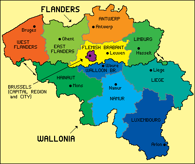
Flanders and Wallonia are each divided into 5 provinces, and as you can see from the map below, Leuven (our city) is the capital of the Flemish Brabant province in Flanders. This is the province that encompasses the Brussels-Capital Region. The border separating Flanders and Wallonia is less than 10 kilometers from where we live right now -- three stops south of us on the train, and we're in a French-speaking town!
 |
| image courtesy of Wikipedia |
So, that's it for the basics. If you have any specific questions, please don't hesitate to leave them in the comments and we'll do our best to answer them.
No comments:
Post a Comment